

PALMELA TRAILS
PR1 Short-distance Trail
The Hillsides of Palmela
and Its Ridges


A signature route of Palmela, rich in natural and archaeological heritage, beginning in the town’s historic centre and winding through the hills that flank the Barris Valley in Serra dos Gaiteiros Ridge and Serra do Louro Ridge.
Serra dos Gaiteiros forms the second line of ridges on the northeastern edge of the Arrábida Natural Park, offering stunning views over the River Sado, the city of Setúbal and the Tróia Peninsula. Here stands the Chapel of Quinta da Escudeira, where on 15 August the municipality’s oldest religious festival and pilgrimage takes place.
Upon reaching the Serra do Louro, a panoramic view opens over the Tagus estuary and its cities. In the company of traditional windmills, the gears that forged the region’s history of grain and bread, the trail highlights key archaeological sites such as Alto da Queimada, a rural Islamic settlement, and Castro de Chibanes, a fortified site with a vast visual domain, classified as a Site of Public Interest in 2011. The path also passes a fossilised oyster bed and several examples of Mediterranean flora, including rosemary, thyme, lavender, and oregano.
From both slopes of Vele dos Barris Valley, one can admire a remarkable botanical diversity forming a mosaic of meadows, olive groves, scrub, and forest. The valley is home to Teatro O Bando, one of Portugal’s oldest cultural cooperatives. The route ends at Quinta do Piloto, which invites visitors to discover its vineyards and winery along with the family history spanning four generations and over a century of tradition in Palmela.
STARTING POINT
(38°34’13.36’ N / 8°54’20.23’ O)
Trail starts and ends at the Alameda 25 de Abril garden, beside the Serra do Louro structure known as Ó Cubo.
IMPORTANT INFORMATION
Trail with no shade; be cautious of heat during the warmer months and slippery ground in winter. The route crosses the CM1054 road twice — walk on the right-hand side for greater safety, as the roadside is narrow and vehicles pass frequently.
TIPS
If travelling by car, parking is recommended at Alameda 25 de Abril. For public transport options, visit www.carrismetropolitana.pt.
SUPPLIES
Available at the start and end of the trail (cafés along Avenida 25 de Abril, the Historic Centre, and the Quinta do Piloto winery).
TECHNICAL SHEET
Type of trail | Circular
Recommended season | September to June
Recommended Direction | Palmela historical center – Serra dos Gaiteiros – Serra do Louro
LENGtH | 11,6 Kms
ESTIMATED DURATION | 4h
Accumulated Elevation Gain | 490m / -490m
Min/max altitude | 40m/224m
DIFFICULTY
1
2
3
3

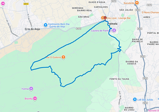
POINTS OF INTEREST
-
D. Maria I Fountain
-
Fonte Nova
-
Fossilised Oyster Bank
-
Alcaria do Alto da Queimada
-
Castro de Chibanes
MILITARY MAP OF PORTUGAL
Sheet 454 | 1/25000, IGeoE