SESIMBRA TRAILS
PR2 Short-distance trail
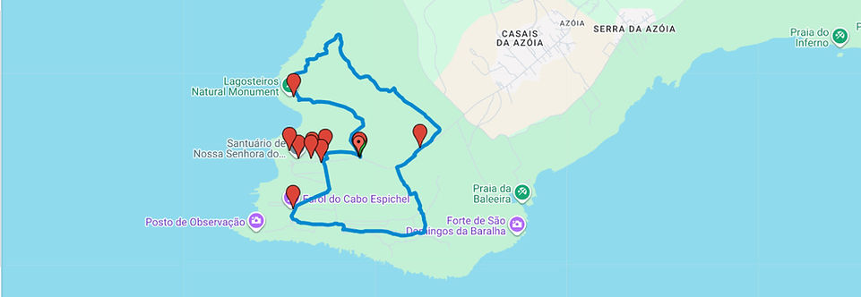
Cabo Espichel


A circular trail beginning and ending on the plateau of Cabo Espichel cape. It overlaps with a section of the GR trail of Arrábida (GR11-E9) and may present some challenges under extreme weather conditions. Hikers should exercise extra caution near the cliffs.
The route starts with a descending dirt track overlooking the Lagosteiros Bay, offering sweeping views of the coastline. Reaching the Pedra da Mua viewpoint, facing south, one gains a new perspective of the Sanctuary of Cabo Espichel and the Ermida da Memória, an architectural ensemble dating from the early 18th century.
Continuing northwards, the western coast comes into view, the coastal arc from Lagoa to Trafaria and, in the distance, the Serra de Sintra range and Lisbon on the northern bank of the Tagus estuary. On the return, heading south, the trail diverges from the GR11-E9, following a more inland path while still under the influence of the sea.
Upon reaching the aqueduct, the trail crosses the access road to Cabo Espichel, winds through grazing fields, and continues toward the lighthouse. Nearing the Sanctuary, it circles the Casa da Água on the southern side and follows the aqueduct back to the starting point.
Cabo Espichel Plateau
Along the coastal section of this trail, hikers can observe several outcrops of sedimentary rocks from the Upper Jurassic (163.5 to 145 million years old) and Cretaceous (145 to 66 million years old) periods. These rocks were deposited in reef and transitional environments and contain a high concentration of marine and lacustrine fossils. At the first stop, looking south toward the Sanctuary and the Ermida da Memória, large, steeply inclined limestone slabs are visible.
Pedra da Mua
Limestone slabs from the Upper Jurassic where several tracks of sauropods (herbivorous quadrupeds) and theropods (bipedal carnivores) can be identified. These ichnofossils (traces of biological activity) form the Pedra da Mua Trackway, providing valuable evidence of the social behaviour of sauropods, showing that they moved in herds.
Lagosteiros fossil trackway
Formed around 130 to 120 million years ago, the Cretaceous Lagosteiros Fossil Trackway developed in a marshy terrain that later solidified into limestone bearing the fossilised footprints of dinosaurs. Here, one can clearly see the tracks of a large quadrupedal herbivore, along with isolated sauropod prints. It remains the only ichnofossil site in Portugal dating from the Lower Cretaceous.
Cabo Espichel Lighthouse
For centuries, the Portuguese coast was known by foreign sailors, especially the English, as “The Black Coast”, due to the absence of any lighting system to aid navigation. In the late 18th century, the Marquis of Pombal ordered the construction of a network of lighthouses to make the coastline safer. The Cabo Espichel Lighthouse, built in 1790 and still operational today, was among the first.
Casa da Água, Horta dos Peregrinos and Aqueduct
Located within the walled Horta dos Peregrinos (Pilgrim’s Garden) compound, the Casa da Água (Water House) is part of the architectural ensemble of the Sanctuary of Cabo Espichel. Water was brought here via an aqueduct from the Mãe de Água spring in Azoia, the last village before reaching Cabo Espichel, three kilometres away.
Flora
The PR1 SSB trail offers the chance to observe examples of Mediterranean vegetation such as kermes oak (Quercus coccifera), strawberry tree (Arbutus unedo), common myrtle (Myrtus communis), mastic tree (Pistacia lentiscus), and gorse (Ulex densus), with its characteristic yellow flowers. At the start of the trail, there are several gum rockrose (Cistus ladanifer) shrubs, a species that can reach nearly two metres in height, with dark green, sticky, glossy leaves, particularly in summer, due to the presence of a highly aromatic resin.
STARTING POINT
38°25'12.9"N 9°12'29.5"W
TIPS
Wear comfortable footwear with good grip (sneakers or hiking boots), and clothing suited to the season. Bring a hat, water and provisions. Take extra precautions on hot days in summer and during heavy rain in winter.
TECHNICAL SHEET
Type of trail | Circular
Recommended season | Spring, Summer and Autumn
Recommended Direction | Anti-clockwise
LENGTH | 8 Km
ESTIMATED DURATION | 3h10
Cumulative elevation gain | +139m / -139m
Min/máx altitude | 48m/148m
DIFFICULTY
3
2
3
3