
SESIMBRA TRAILS
PR3 Short-distance trail
Chã dos Navegantes


A circular trail beginning and ending near Cabo Espichel cape. The trail features steep inclines and can be challenging in adverse weather conditions.
The hike begins heading south, descending sharply over limestone blocks and along paths bordered by typical Mediterranean scrub.
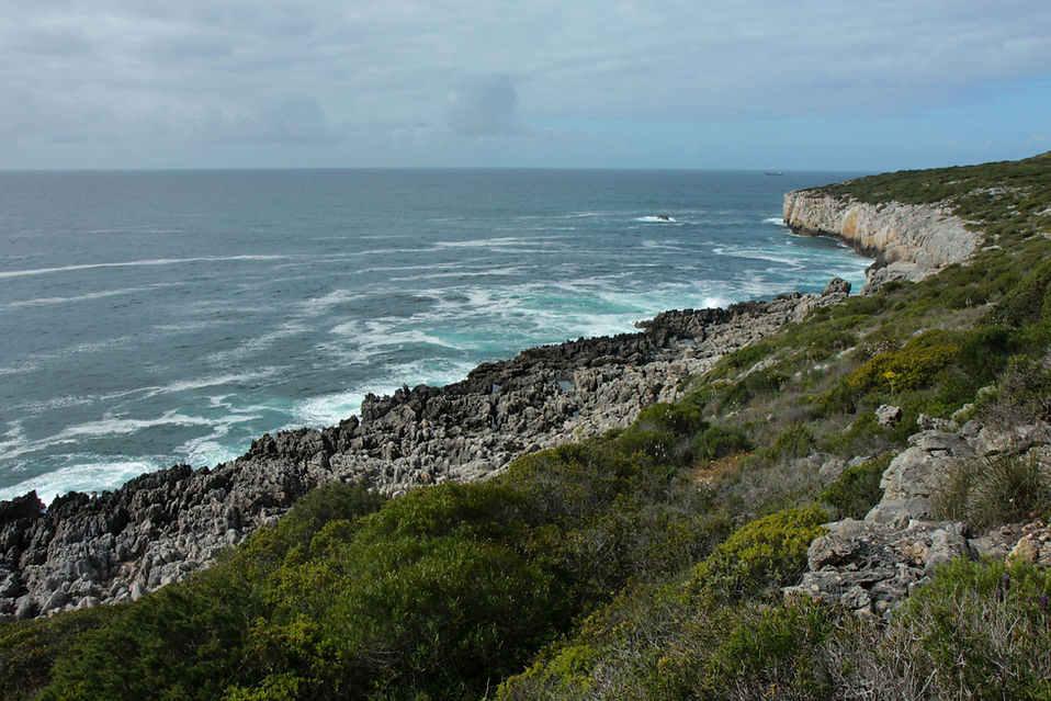
At the end of the descent, hikers reach a flat area at the edge of the cliffs known as the rechã, offering striking coastal views where limestone has been sculpted by the sea. From here, one can admire the imposing cliffs that define the southern coastline.
Rechã
A marine abrasion platform located above the current sea level, showing that the shoreline once stood there. Cabo Espichel itself is a marine erosion platform, now about 100 metres above sea level, marking the average level of the sea during the last interglacial period — roughly 100,000 to 120,000 years ago. The rechã, west of the São Domingos da Baralha Fort, stands about seven metres above today’s mean sea level, shaped by the constant action of the sea and erosion, giving the rock its rugged appearance.
São Domingos da Baralha Fort
A small 17th-century fortification of rectangular design. From the remains, one can still see the main wall, the gate, the old cistern, and the chapel. This fort once formed part of a chain of coastal outposts built to protect the coast from pirate raids, stretching from Lagoa de Albufeira to Outão.
Flora and Fauna
The Espichel bindweed (Convolvulus fernandesii) and Espichel spurge (Euphorbia pedroi) are two endemic species found only within the Arrábida Natural Park, with their entire global distribution limited to the area between Cabo Espichel and Sesimbra. They thrive in sunny, vertical environments on thin, rocky soils along the limestone cliffs that frame the trail. The route also features juniper (Juniperus turbinata), a hardy shrub or small tree, with scalelike ovate leaves, common in dry, coastal areas of Portugal. When dominant, it forms dense juniper groves.
The coastal cliffs are also an important nesting ground for birdlife, where it is possible to spot raptors such as the peregrine falcon (Falco peregrinus) and Bonelli’s eagle (Aquila fasciata).
STARTING POINT
38°25'12.9"N 9°12'29.5"W
SUPPLIES
There is a café and public restrooms near the Sanctuary of Our Lady of Cabo Espichel, about 500 meters from the starting point of the trail.
TIPS
Wear comfortable footwear with good grip (sneakers or hiking boots), and clothing suited to the season. Bring a hat, water and provisions. Take extra precautions on foggy days, hot days in summer and during heavy rain in winter.
TECHNICAL SHEET
Type of trail | Circular
Recommended season | All year round
Recommended Direction | A – B
LENGTH | 5 Km
ESTIMATED DURATION | 1h30
Cumulative elevation gain | +116m / -116m
Min/máx altitude | 32m/148m
DIFFICULTY
4
2
3
2

